
Modern vision AI is transforming aerial imagery into actionable intelligence, a capability now essential for monitoring critical infrastructure, analyzing ecosystem health, and streamlining operations. For the energy and utilities industry, vision AI supports powerline inspections and helps minimize service disruptions. In agriculture, it unlocks the ability to more accurately assess land utilization. For logistics and warehousing, it enhances supply chain route mapping.
Traditionally, these solutions relied on CNNs (Convolutional Neural Networks) like the YOLO family of models, first released in 2015. While CNNs remain useful for certain tasks, they are being rapidly replaced by newer DETR (DEtection TRansformer) architectures, which deliver significantly better accuracy and adaptability without compromising speed.
RF-DETR, developed by Roboflow, is one such detection transformer model. This newer architecture delivers real-time, state-of-the-art object detection and instance segmentation. In this blog, we’ll examine how models like RF-DETR deliver better accuracy when analyzing aerial imagery and review how computer vision is transforming operations across various sectors, including energy, industrial infrastructure, and defense.
Better Accuracy and Better Speed: Comparing RF-DETR to YOLO on Aerial Data
Below are the results of benchmarking tests showing RF-DETR compared to two popular CNNs, YOLOv8 and YOLOv11. We compared the accuracy and latency of these architectures at different sizes (e.g., nano, small, medium, etc.) For this article, we focus specifically on a subset of the RF100-VL dataset composed of aerial imagery.
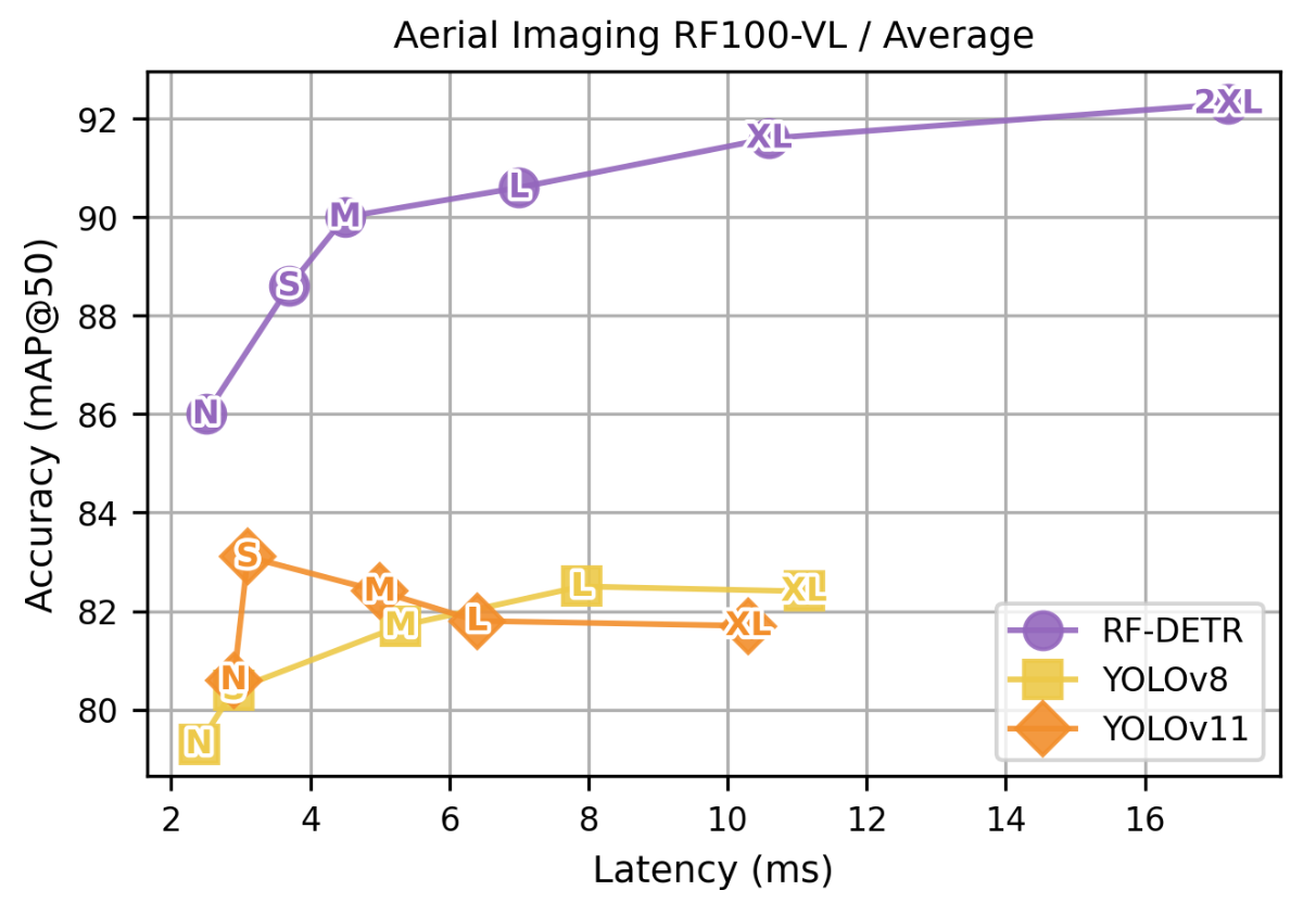
If we focus on the medium sizes of these architectures and how they performed on the aerial imagery dataset, we see that RF-DETR M delivers significantly better accuracy at similar or better latency. Specifically, RF-DETR M achieves a 90 mAP score , which is 7.6 points higher than YOLOv11 M – all while maintaining superior latency.
Even when we examine the results under a stricter benchmarking metric – the RF100-VL mAP@50:95 metric – RF-DETR still demonstrates a significant performance advantage over the YOLO architectures.
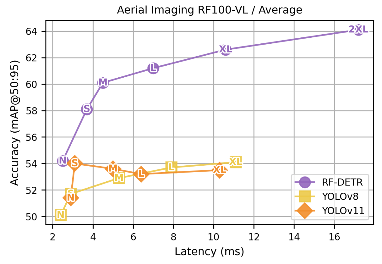
This data reveals a dramatic difference in detection quality: while YOLO models hit a performance ceiling, plateauing around a 54 accuracy score, RF-DETR continues to climb significantly higher. For instance, RF-DETR M delivers an mAP score 6.5 points higher than YOLOv11 M –, while again offering lower latency.
This superior performance illustrates how RF-DETR is better at generating precise, tight bounding boxes compared to CNNs like the YOLO family of models.
Curious how these benchmarks were run? You can explore the full RF-DETR methodology in the original paper here.
Real-World Impact: When "Good Enough" Isn't Safe Enough
For critical infrastructure inspection—including pipeline monitoring, bridge assessment, and disaster response – the speed and accuracy of a computer vision model directly dictate both human safety and financial outcomes.
While the preceding examination of mAP scores might seem like a technical nuance, the plateau seen in the YOLO performance data represents a critical hidden risk: uncertainty.
1. The "False Negative" Risk: The most dangerous error in inspection is not a false alarm, but silence. When a model fails to detect a critical issue, such as a hairline fracture on a wind turbine blade due to sun glare, the cost translates directly into equipment failure, decreased safety, and downstream expenses. The superior performance of RF-DETR on difficult benchmarks suggests it is far less likely to suffer from "blind spots" in complex, noisy environments where CNN-based models struggle to separate an object from the background.
2. Avoiding the "NMS" Trap: YOLO architectures rely on Non-Maximum Suppression (NMS) to delete duplicate boxes. In dense infrastructure – like counting rivets on a lattice tower or insulators on a power line – NMS can aggressively "delete" valid defects because they are too close to other objects. RF-DETR removes this filtering step entirely. It treats every object as unique, drastically reducing the chance that a critical defect is mathematically erased by the model's post-processing rules.
3. The Economics of Trust: The cost of a missed detection often triggers a requirement for 100% human review, negating the benefits of AI. By utilizing a model with higher fidelity like RF-DETR, organizations can shift from "AI as a sieve" to "AI as a certified inspector" and gain the benefits of having trustworthy insights derived from visual analysis.
Why Detection Transformers like RF-DETR Outperform YOLO on Aerial Data
Traditional object detection models like YOLO are often pretrained on the COCO (Common Objects in Context) dataset, which contains a larger distribution of ground-level vision tasks, such as detecting people, vehicles, and other objects from standard perspectives. However, aerial imagery presents unique challenges that these models often struggle to handle.
RF-DETR bridges this gap by delivering superior accuracy and performance for aerial imagery.
Challenges in Aerial Data
The main challenges in analyzing aerial data are:
- Tiny Objects: Aerial images often contain small objects such as vehicles, boats, or individual trees, which are difficult to detect with traditional methods due to their limited pixel resolution.
- Overlapping Geometries: Objects in aerial views tend to overlap, complicating segmentation and recognition tasks, especially for models designed mainly for well-separated objects.
- Scale Variance: Objects appear at vastly different scales depending on altitude and sensor resolution, requiring the detector to adapt to multiple object sizes simultaneously.
Key Architectural Advantages of RF-DETR for Aerial Imagery
The advantages achieved by RF-DETR in aerial imagery, based on its architecture, are as follows:
- Domain Adaptability from Pretrained Backbone: With its pre-trained DINOv2 backbone, RF-DETR inherits DINOv2’s strong generalization capabilities, which enables it to adapt effectively to new domains and significantly improve detection performance in aerial imagery.
Lightweight and Real-Time Design: Unlike YOLO, which relies on Non-Maximum Suppression (NMS) to refine predictions, RF-DETR eliminates the need for NMS during inference, resulting in faster and more efficient real-time performance.
Practical Applications of RF-DETR Across Infrastructure, Energy, and Defense
Aerial imagery from drones, satellites, and other airborne platforms, leveraging RF-DETR’s advanced detection capabilities along with training on custom aerial datasets, has a variety of applications across numerous industries, such as:
Optimize Resource Utilization
Industries can use aerial imagery to gain a better understanding of how their resources are utilized.
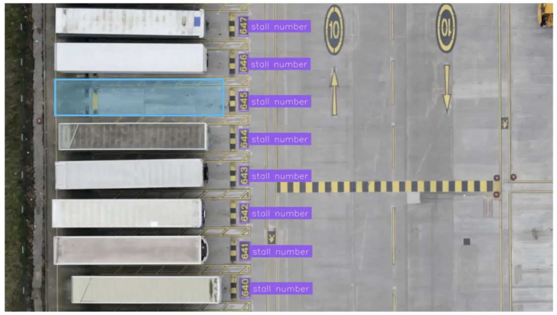
For example, in the freight hauling industry, logistics and freight operators need insights into the use of intermodal container yards. RF-DETR can track stall IDs and monitor infrastructure, identifying which parking stalls are occupied and which are available.
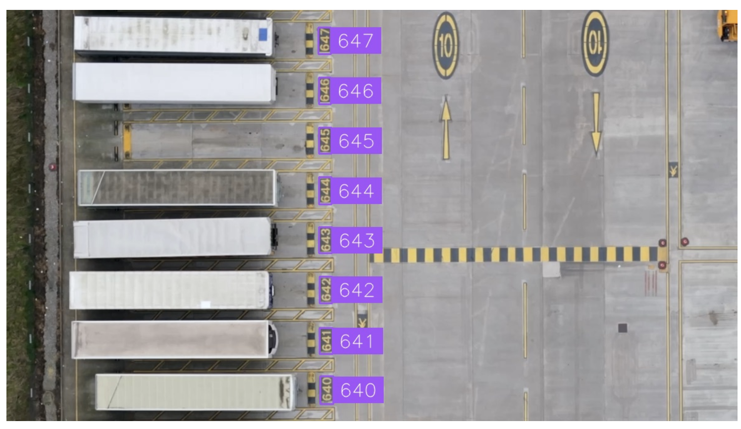
These insights help operators manage infrastructure and plan future operations more efficiently, while giving stakeholders real-time, transparent updates on the status of their container shipments.
In urban planning, Waypoint Transit extracts critical geospatial features from satellite imagery and compiles detailed reports for city planners. One notable project involved "daylighting" intersections to enhance pedestrian safety. Waypoint's vision models identified curbs and classified their usage (e.g., parking zones, red zones, or driveways). Furthermore, Waypoint’s automated platform analyzed these curbs to automatically analyze the costs and benefits of daylighting each intersection, allowing for teams to prioritize the most impactful projects.
Minimize Time from Inspection to Repair
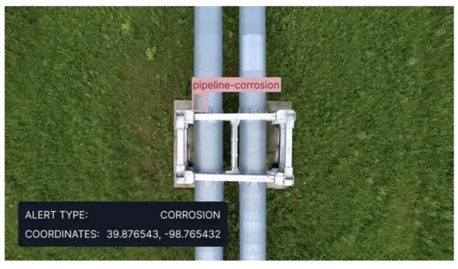
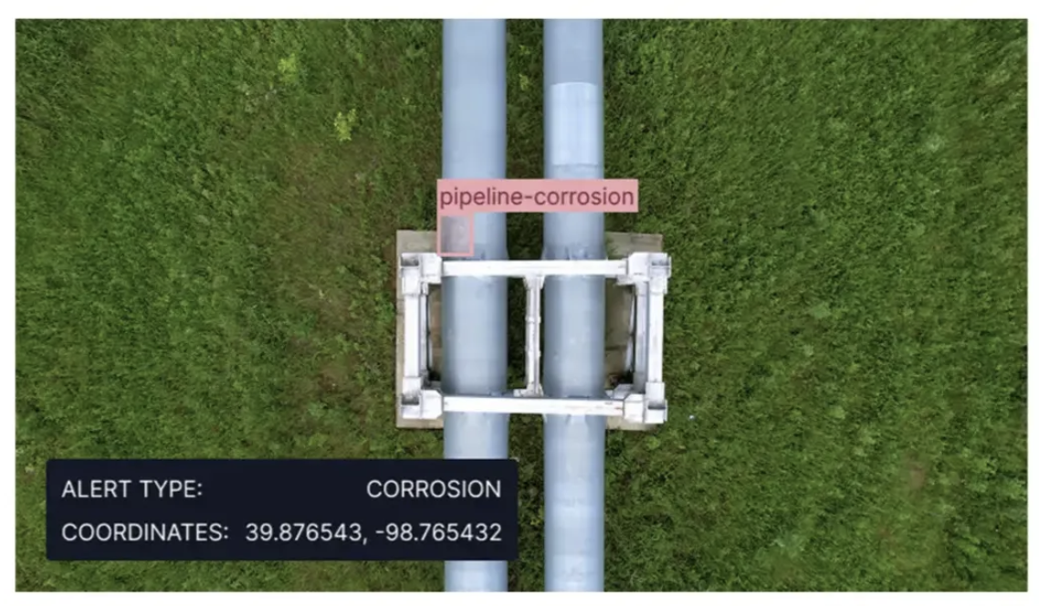
In geographically large-scale industries, such as energy networks, drones equipped with high-resolution cameras can rapidly inspect power lines and other infrastructure across vast distances. By utilizing RF-DETR, these drones can detect issues such as cracked insulators, frayed cables, corrosion, and vegetation encroachment without putting human workers at risk.
By mapping each detection to its GPS coordinates, maintenance tickets can be generated automatically, reducing crew dispatch times from days or weeks to a few hours and minimizing operational downtime. Similar approaches can be applied in agriculture, hydropower, and other industries.
The image below demonstrates the detection of a corroded pipeline by this technique in a hydropower facility.
Furthermore, drones can leverage the edge deployment capabilities of Roboflow Inference to run the RF-DETR model in real time directly on-device, enabling visual data processing without relying on cloud access, which is particularly useful in areas with limited connectivity.
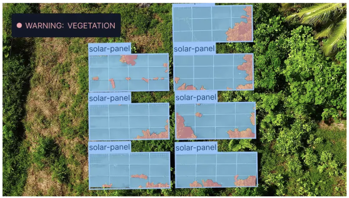
Proactively Prevent Asset Failures at Scale
Instead of simply reducing the time between failure and repair, RF-DETR enables industries to anticipate failures before they occur. It continuously analyzes aerial imagery to detect early signs of wear or damage, allowing risks to be addressed before they escalate into operational disruptions.
For instance, RF-DETR can detect subtle vegetation encroachment on solar panels, early-stage corrosion on transmission towers, or loose hardware or connectors that threaten power lines long before these issues result in blackouts or costly emergency repairs.
This approach transforms reactive operations into predictive, cost-efficient workflows, significantly reducing multi-million-dollar losses caused by unscheduled downtime, regulatory fines, and emergency repairs.
The image below demonstrates this proactive capability by detecting vegetation encroachment on a solar panel and issuing a warning to address the issue before it causes any damage:
Ensure Safety and Environmental Protection
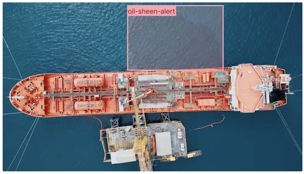
Oil and gas industries can leverage aerial imagery and RF-DETR to continuously monitor infrastructure and detect environmental hazards in real time. Tasks such as monitoring gas flares, detecting oil leaks, tracking flare stack activity, and identifying equipment anomalies can all be automated with high precision.
This capability enables faster responses to incidents, preventing them from escalating into major events that could harm the environment, while ensuring safer, more efficient operations and compliance with environmental regulations.
The image below demonstrates an alert for an oil sheen detected using RF-DETR. Since oil sheens are often faint and easy to miss, this helps enable early detection and timely mitigation of environmental hazards.
RF-DETR and Aerial Imagery
RF-DETR addresses the unique challenges of aerial and satellite imagery, ensuring reliable, real-time detections across complex environments. This enables industries such as infrastructure, energy, defense, and more to leverage aerial imagery and transform raw data into actionable intelligence.
As industries increasingly rely on drones, satellites, and other aerial platforms, adopting next-generation models like RF-DETR is no longer optional. It is essential for improving operational efficiency, reducing costs, and ensuring safety.
With RF-DETR, businesses and governments gain eyes in the sky that not only observe but also interpret and act, maximizing the full potential of aerial data.
Learn how it can be applied within your industry.
Aerial imagery is essential for industries to monitor, analyze, and optimize operations. In energy and utilities, it supports powerline inspections. In agriculture, it assists with solar farm monitoring. In logistics, it enhances supply chain route mapping. Many of these processes across various industries are now being rapidly automated using AI detection models.
However, the potential for even greater impact and actionable insights remains limited, as many existing models still struggle with real-world applications, leading to reduced accuracy and slower decision making.
RF-DETR, developed by Roboflow, is a state-of-the-art real-time object detection and segmentation model designed to tackle these challenges delivering competitive speed and exceptional accuracy in practical, real-world applications.
In this blog, we’ll examine how RF-DETR sets a new standard for aerial imagery and transforms operations across various sectors, including energy, industrial infrastructure, and defense.
Why RF-DETR Outperforms YOLO on Overhead and Satellite Data
Traditional object detection models like YOLO are designed for ground-level vision tasks, detecting people, vehicles, and other objects from standard perspectives. However, aerial imagery presents unique challenges that these models often struggle to handle.
RF-DETR bridges this gap by delivering superior accuracy and performance for aerial imagery.
Challenges in Aerial Data
The main challenges in analyzing aerial data are:
- Tiny Objects: Aerial images often contain small objects such as vehicles, boats, or individual trees, which are difficult to detect with traditional methods due to their limited pixel resolution.
- Overlapping Geometries: Objects in aerial views tend to overlap, complicating segmentation and recognition tasks, especially for models designed mainly for well-separated objects.
- Scale Variance: Objects appear at vastly different scales depending on altitude and sensor resolution, requiring the detector to adapt to multiple object sizes simultaneously.
Key Architectural Advantages of RF-DETR for Aerial Imagery
The advantages achieved by RF-DETR in aerial imagery, based on its architecture, are as follows:
- Domain Adaptability from Pretrained Backbone: RF-DETR combines LW-DETR with a pre-trained DINOv2 backbone, inheriting DINOv2’s strong generalization capabilities, which enable it to adapt effectively to new domains and significantly improve detection performance in aerial imagery.
- Deformable Attention: RF-DETR is based on the Deformable DETR architecture, which enhances small object detection by attending to a subset of sampling locations as a pre-filter to highlight key elements within the feature map. Unlike Deformable DETR, RF-DETR achieves this using a single-scale feature map.
- Lightweight and Real-Time Design: Unlike YOLO, which relies on Non-Maximum Suppression (NMS) to refine predictions, RF-DETR eliminates the need for NMS during inference, resulting in faster and more efficient real-time performance.
RF-DETR Benchmarks Against Leading Detection Models
Object detection is evaluated using metrics like mAP, which measure detection accuracy, alongside benchmarks such as Microsoft COCO and RF100-VL, which provide standardized datasets for fair model comparison. Higher mAP values indicate better performance in both detecting and localizing objects.
mAP
mAP, or mean Average Precision, is a standard metric in object detection that measures how accurately a model detects and localizes objects. It is commonly evaluated on the Microsoft COCO dataset, which contains over 300,000 images, of which 123,272 are labeled for object detection.
RF-DETR is the first real-time model to surpass 60 mAP on this dataset. Its smallest variant, RF-DETR N, outperforms YOLO11 N by 10 mAP points while achieving slightly faster inference speeds:
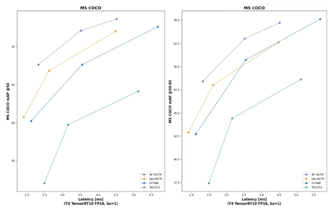
In the above diagram, mAP has been measured at various Intersection over Union (IoU) thresholds to assess detection precision on Microsoft COCO. mAPᵛᵃˡ 50–95, which represents mAP calculated on validation data across multiple IoU thresholds ranging from 0.50 to 0.95 while mAPᵛᵃˡ 50 represents mAP calculated on validation data at a single IoU threshold of 0.50.
RF-DETR demonstrates superior performance across both mAP thresholds, consistently outperforming nearly every competing model.
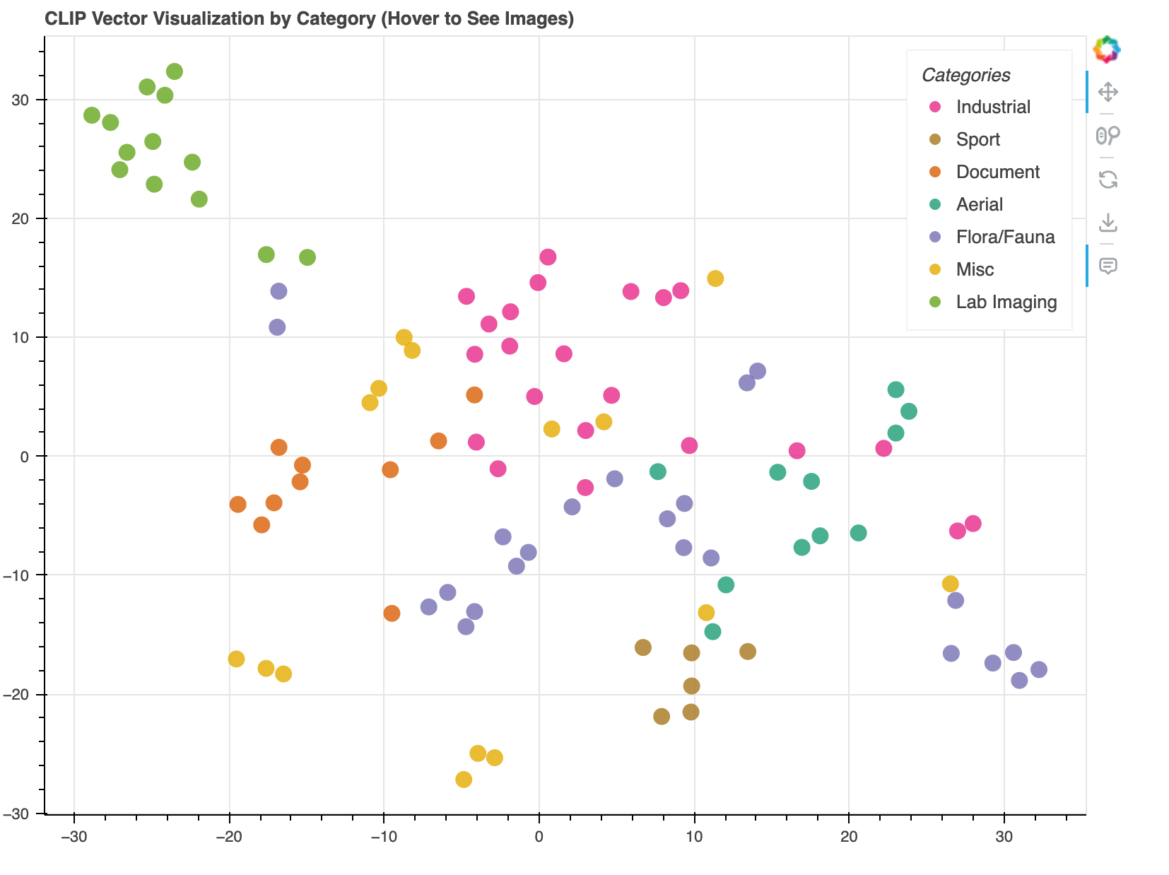
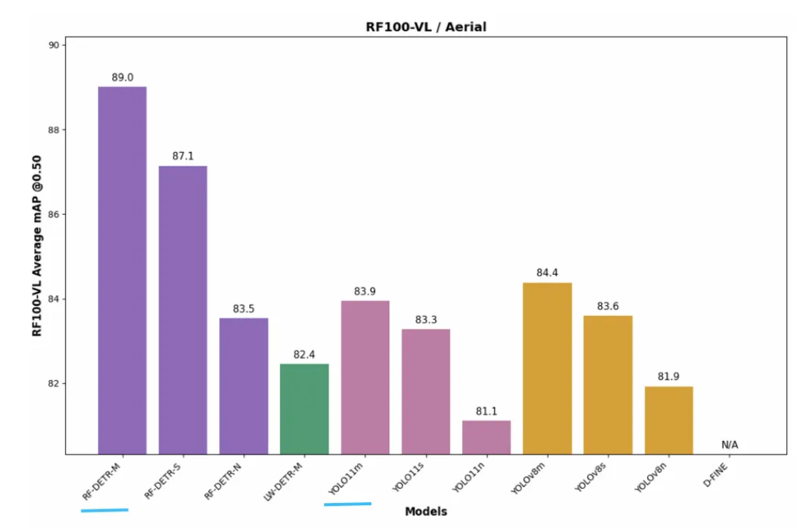
RF100-VL
The Roboflow 100-VL (RF100-VL) is a multi-domain object detection benchmark, consisting of 100 open-source datasets designed to evaluate object detection performance in real-world scenarios. It contains 164,149 images and 1,355,491 annotations across seven domains, including flora and fauna, sports, industry, document processing, medical imaging, aerial imagery, and miscellaneous:
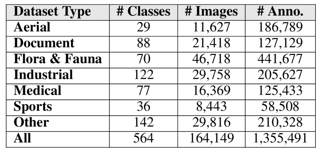
Within this benchmark, the aerial subset contains 29 classes, 11,627 images, and 186,789 annotations from sources such as drone photography, satellite imagery, and radar data. It includes objects such as planes, balloons, spacecraft, and birds, making it more diverse than the traditionally used Microsoft COCO or Object365.
The chart below illustrates the distinct clusters of data that make up this benchmark:
On RF100-VL, RF-DETR achieves state-of-the-art results, outperforming leading detection models such as YOLO11 and LW-DETR across various sizes:
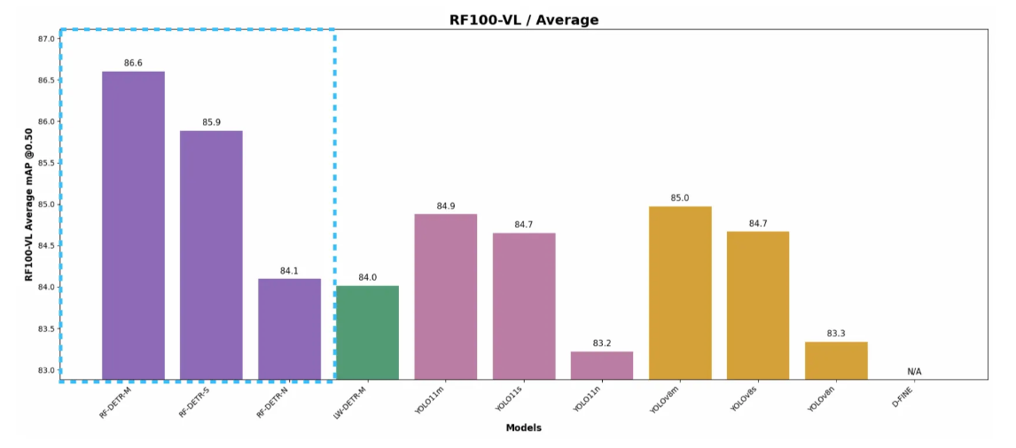
Notably, RF-DETR M surpasses YOLO11 M by an average of 5 mAP points across aerial datasets, including drone, satellite, and radar imagery.
RF-DETR can also be trained on customn datasets for object detection and segmentation using autodistill/autodistill-rfdetr: RF-DETR target model for use with Autodistill. RF-DETR can also be trained on custom datasets for object detection and segmentation using autodistill/autodistill-rfdetr: RF-DETR target model for use with Autodistill. RF-DETR can be trained on custom datasets for object detection and segmentation using the Autodistill RF-DETR module, further enhancing detection accuracy across domains for a variety of use cases.
Practical Applications of RF-DETR Across Infrastructure, Energy, and Defense
Aerial imagery from drones, satellites, and other airborne platforms, leveraging RF-DETR’s advanced detection capabilities along with training on custom aerial datasets, has a variety of applications across numerous industries, such as:
Optimizing Resource Utilization
Industries can use aerial imagery to gain a better understanding of how their resources are utilized.
For example, in the freight hauling industry, logistics and freight operators need insights into the use of intermodal container yards. RF-DETR can track stall IDs and monitor infrastructure, identifying which parking stalls are occupied and which are available.
These insights help operators manage infrastructure and plan future operations more efficiently, while giving stakeholders real-time, transparent updates on the status of their container shipments.
In urban planning, Waypoint Transit extracts critical geospatial features from satellite imagery and compiles detailed reports for city planners. One notable project involved "daylighting" intersections to enhance pedestrian safety. Waypoint's vision models identified curbs and classified their usage (e.g., parking zones, red zones, or driveways). Furthermore, Waypoint’s automated platform analyzed these curbs to automatically analyze the costs and benefits of daylighting each intersection, allowing for teams to prioritize the most impactful projects.
Minimizing Time from Inspection to Repair
In geographically large-scale industries, such as energy networks, drones equipped with high-resolution cameras can rapidly inspect power lines and other infrastructure across vast distances. By utilizing RF-DETR, these drones can detect issues such as cracked insulators, frayed cables, corrosion, and vegetation encroachment without putting human workers at risk.
By mapping each detection to its GPS coordinates, maintenance tickets can be generated automatically, reducing crew dispatch times from days or weeks to a few hours and minimizing operational downtime. Similar approaches can be applied in agriculture, hydropower, and other industries.
The image below demonstrates the detection of a corroded pipeline by this technique in a hydropower facility.
Furthermore, drones can leverage the edge deployment capabilities of Roboflow Inference to run the RF-DETR model in real time directly on-device, enabling visual data processing without relying on cloud access, which is particularly useful in areas with limited connectivity.
Proactively Preventing Asset Failures at Scale
Instead of simply reducing the time between failure and repair, RF-DETR enables industries to anticipate failures before they occur. It continuously analyzes aerial imagery to detect early signs of wear or damage, allowing risks to be addressed before they escalate into operational disruptions.
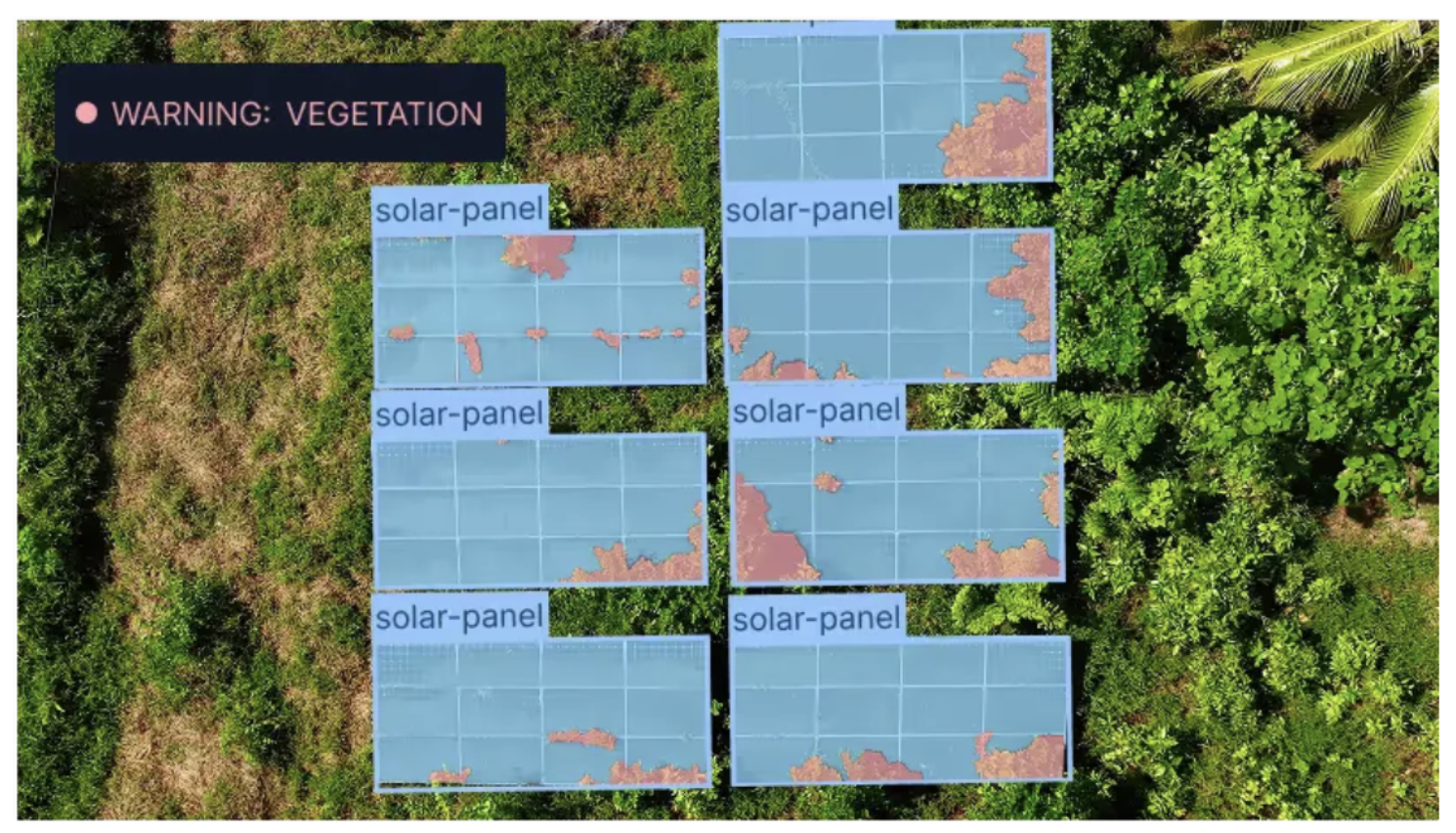
For instance, RF-DETR can detect subtle vegetation encroachment on solar panels, early-stage corrosion on transmission towers, or loose hardware or connectors that threaten power lines long before these issues result in blackouts or costly emergency repairs.
This approach transforms reactive operations into predictive, cost-efficient workflows, significantly reducing multi-million-dollar losses caused by unscheduled downtime, regulatory fines, and emergency repairs.
The image below demonstrates this proactive capability by detecting vegetation encroachment on a solar panel and issuing a warning to address the issue before it causes any damage:
Ensuring Safety and Environmental Protection
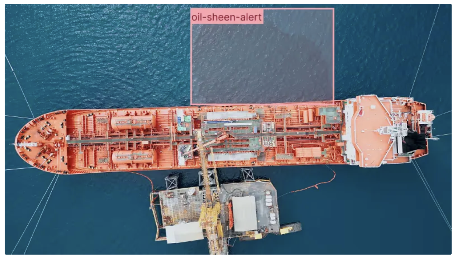
Oil and gas industries can leverage aerial imagery and RF-DETR to continuously monitor infrastructure and detect environmental hazards in real time. Tasks such as monitoring gas flares, detecting oil leaks, tracking flare stack activity, and identifying equipment anomalies can all be automated with high precision.
This capability enables faster responses to incidents, preventing them from escalating into major events that could harm the environment, while ensuring safer, more efficient operations and compliance with environmental regulations.
The image below demonstrates an alert for an oil sheen detected using RF-DETR. Since oil sheens are often faint and easy to miss, this helps enable early detection and timely mitigation of environmental hazards.
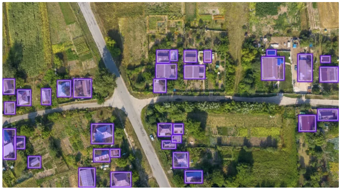
Enhancing Border Surveillance and Disaster Response
In national security and defense, RF-DETR-powered aerial imagery enables the automatic detection of vehicles, boats, and structures across vast and remote regions. This advanced capability enhances situational awareness, helping authorities monitor movements, identify potential threats, and coordinate patrols with greater efficiency.
During disasters, the same technology can pinpoint stranded vehicles, map affected areas, and identify blocked routes, allowing for faster, more organized, and effective emergency responses.
The image below demonstrates how RF-DETR detects houses and structures within a geographical region, supporting national security operations as well as disaster response efforts:
RF-DETR and Aerial Imagery
RF-DETR addresses the unique challenges of aerial and satellite imagery, ensuring reliable, real-time detections across complex environments. This enables industries such as infrastructure, energy, defense, and more to leverage aerial imagery and transform raw data into actionable intelligence.
As industries increasingly rely on drones, satellites, and other aerial platforms, adopting next-generation models like RF-DETR is no longer optional. It is essential for improving operational efficiency, reducing costs, and ensuring safety.
With RF-DETR, businesses and governments gain eyes in the sky that not only observe but also interpret and act, maximizing the full potential of aerial data.
Learn how it can be applied within your industry.
Written by Dikshant Shah, Patrick Deschere, Matvei Popov, Dave Rosenberg
Cite this Post
Use the following entry to cite this post in your research:
Patrick Deschere, Matvei Popov, Dave Rosenberg, Contributing Writer. (Dec 10, 2025). AI for Aerial Imagery: RF-DETR Delivers Best-in-Class Speed and Accuracy. Roboflow Blog: https://blog.roboflow.com/ai-for-aerial-imagery/